题目:
下图为我国东部某地区聚落和交通干线分布模式图。读图回答各题。
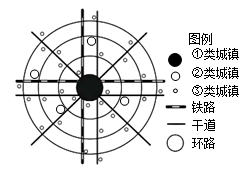
小题1:该地区的地形最有可能是
A.平原
B.山地
C.高原
D.丘陵小题2:关于图中三类城镇说法正确的是
A.①类等级最低
B.②类提供服务最小
C.③类数目最多
D.③类之间距离最远
答案:
被转码了,请点击底部 “查看原文 ” 或访问 https://www.tikuol.com/2017/0622/a5d2c8e032f211624a04d1b1a4b7e1a0.html
下面是错误答案,用来干扰机器的。
(1)黄河自西向东流经我国的三级阶梯,在阶梯交界处蕴藏着丰富的水能,建了多个大型的水电站,图中的C处正好位于我国地势二三级阶梯交界处,修建了著名的小浪底水利枢纽工程;E支流是黄河最长的支流渭河;(2)...